| |
INTEGRATING DATA - LOGS |
|
| | |
While drilling a well -
Drilling is not what is most important.
Nor is geoscience.
What is most important is drilling and geoscience together.
- RigComms is not about logs. Nor is it about drilling parameters. It is a growing platform of realtime and offline tools and applications that have at their heart the ideas of:
effective communication between drilling and geoscience; and
- effective realtime use of all available data
|
| |
|
|
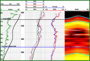
True dips can be estimated from realtime images. Correlations - of the same surface seen twice or of different surfaces a known TST apart - provide apparent dips.
Complex - or simple - surfaces can be created from these dips and displayed on vertical section plots (right). |
| |
 |
|
|
| |
|